


IMAGE INTELLIGENCE (IMINT)
(Imagery Intelligence):
Image Analysis (IA):
It is actually interpreting often all data such as photos, video, satellite images and maps and seeing what they actually show. Image analysts distinguish with useful things in critical data..

Image Intelligence (IMINT) (Imagery Intelligence):
Image intelligence is obtained from photographs and images collected through different sensors such as satellites, infrared, UAV, submarines, laser. Image Intelligence (IMINT) refers to information gathered and produced from photographs and images.
Geospatial Intelligence (GEOINT)
It is the analysis and visual representation of security related activities on earth. This image is produced through image intelligence and geospatial information integration.
What is the difference between GEOINT and IMINT?
It is everything you can see or know about the world. Geospatial Intelligence (GEOINT) is a similarity of any natural or people-made feature, as well as image and Image Intelligence (IMINT) which are generated information intelligence obtained by interpreting and analyzing images.
Image Intelligence (IMINT) in the historical process:
İlk olarak It started to be used in the 2nd world war. During this war through the development of technology, cold-resistant cameras were produced preventing freezing during high flight. In addition, these developments enabled the widespread use of Image Intelligence methods in ancient world history.
Image intelligence that is more advanced and widely used today.
It is known that the first aerial photograph was taken in 1858 by a hot air balloon attached to the ground. A similar method was also used in the American civil war for 4 years..
From the evidence of history these and similar things show that equipment such as zeppelins, balloons and kites were used in image intelligence studies.
In the 1900s, aircraft began to be produced to collect private and secret intelligence and to make research and investigation facilities. Unnecessary parts and equipment were removed on these planes and efficient parts and equipment were added to their places that could benefit the photograph to be obtained.
How many types of image processing are there?
There are two types of methods used for image processing. These are analog and digital image processing. Analog image processing can be used for copies such as photographs. Image analysts use various fundamentals of interpretation while using these techniques.
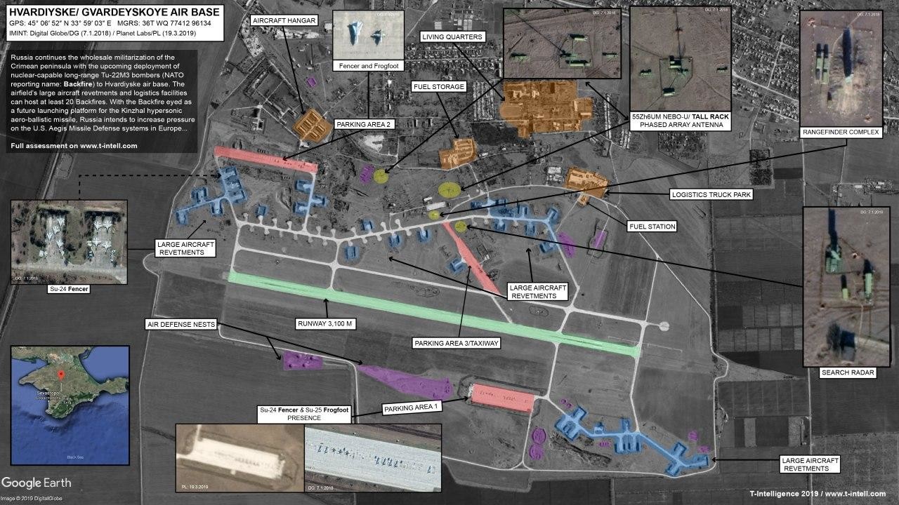
Image Intelligence (IMINT) categories.
The intelligence cycle is actively cooperating and consists of six steps. These are: 1. Requirements 2. Planning and direction 3. Collection 4. Processing and use 5. Analysis and production and 6. Publication.
Image Intelligence (IMINT) nowadays:
Nowadays, Image intelligence data are more developed. It's collected by different methods such as security cameras, Unmanned Aerial Vehicles (UAV) , MOBESEs (Traffic Cameras) and intelligence satellites.
As we all know, there are security cameras almost everywhere in order to monitor entrances and exits and to monitor suspicious persons, to detect and report possible robbery and theft. According to December 2, 2019 data; China's 庆 市 (Chongqing) province was chosen as the country with the highest number of security cameras with 2,500,000 cameras.
Unmanned aerial vehicles (UAVs), which we all hear in the news and are used for different purposes such as firefighting, also used for image intelligence. As I mentioned, it is used for purposes such as learning the situation of the region.
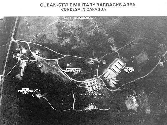
Intelligence satellites contain advanced military and software, these are more powerful and developed than normal satellites, and created for intelligence and information gathering. The general purpose of these satellites is to research, examine and photograph the land in the specified region.
In which field is Image Intelligence actively plays a role?
Image Intelligence (IMINT) plays an active role in the military, national and civilian field. Considering the current technological developments and trends, it is observed that the collected images will increase and the analysis intelligence form of these images will develop much more actively.
In which things can Image Intelligence develop in the future?
Image Intelligence (IMINT) has a high potential for development in identifying and warning processes as an important intelligence unit, supporting security services, armed forces, monitoring gun control agreements, refugee flows, narcotics and ecological problems.
(Imagery Intelligence):
Image Analysis (IA):
It is actually interpreting often all data such as photos, video, satellite images and maps and seeing what they actually show. Image analysts distinguish with useful things in critical data..
Image Intelligence (IMINT) (Imagery Intelligence):
Image intelligence is obtained from photographs and images collected through different sensors such as satellites, infrared, UAV, submarines, laser. Image Intelligence (IMINT) refers to information gathered and produced from photographs and images.
Geospatial Intelligence (GEOINT)
It is the analysis and visual representation of security related activities on earth. This image is produced through image intelligence and geospatial information integration.
What is the difference between GEOINT and IMINT?
It is everything you can see or know about the world. Geospatial Intelligence (GEOINT) is a similarity of any natural or people-made feature, as well as image and Image Intelligence (IMINT) which are generated information intelligence obtained by interpreting and analyzing images.
Image Intelligence (IMINT) in the historical process:
İlk olarak It started to be used in the 2nd world war. During this war through the development of technology, cold-resistant cameras were produced preventing freezing during high flight. In addition, these developments enabled the widespread use of Image Intelligence methods in ancient world history.
Image intelligence that is more advanced and widely used today.
It is known that the first aerial photograph was taken in 1858 by a hot air balloon attached to the ground. A similar method was also used in the American civil war for 4 years..
From the evidence of history these and similar things show that equipment such as zeppelins, balloons and kites were used in image intelligence studies.
In the 1900s, aircraft began to be produced to collect private and secret intelligence and to make research and investigation facilities. Unnecessary parts and equipment were removed on these planes and efficient parts and equipment were added to their places that could benefit the photograph to be obtained.
How many types of image processing are there?
There are two types of methods used for image processing. These are analog and digital image processing. Analog image processing can be used for copies such as photographs. Image analysts use various fundamentals of interpretation while using these techniques.
Image Intelligence (IMINT) categories.
The intelligence cycle is actively cooperating and consists of six steps. These are: 1. Requirements 2. Planning and direction 3. Collection 4. Processing and use 5. Analysis and production and 6. Publication.
Image Intelligence (IMINT) nowadays:
Nowadays, Image intelligence data are more developed. It's collected by different methods such as security cameras, Unmanned Aerial Vehicles (UAV) , MOBESEs (Traffic Cameras) and intelligence satellites.
As we all know, there are security cameras almost everywhere in order to monitor entrances and exits and to monitor suspicious persons, to detect and report possible robbery and theft. According to December 2, 2019 data; China's 庆 市 (Chongqing) province was chosen as the country with the highest number of security cameras with 2,500,000 cameras.
Unmanned aerial vehicles (UAVs), which we all hear in the news and are used for different purposes such as firefighting, also used for image intelligence. As I mentioned, it is used for purposes such as learning the situation of the region.
Intelligence satellites contain advanced military and software, these are more powerful and developed than normal satellites, and created for intelligence and information gathering. The general purpose of these satellites is to research, examine and photograph the land in the specified region.
In which field is Image Intelligence actively plays a role?
Image Intelligence (IMINT) plays an active role in the military, national and civilian field. Considering the current technological developments and trends, it is observed that the collected images will increase and the analysis intelligence form of these images will develop much more actively.
In which things can Image Intelligence develop in the future?
Image Intelligence (IMINT) has a high potential for development in identifying and warning processes as an important intelligence unit, supporting security services, armed forces, monitoring gun control agreements, refugee flows, narcotics and ecological problems.
Translator: Shezzar
Source: https://www.turkhackteam.org/sosyal...haberlesme-amacli-istihbarat.html#post9145179
Source: https://www.turkhackteam.org/sosyal...haberlesme-amacli-istihbarat.html#post9145179
Son düzenleme: